
Peru’s Band of Holes Mystery Finally Explained
In the enigmatic Pisco Valley of southern Peru, the Monte Sierpe site—popularly known as the “Band of Holes”—consists of thousands of precisely aligned circular pits that have baffled researchers for generations. Recent investigations employing cutting-edge drone mapping and detailed microbotanical examinations have provided compelling evidence suggesting these formations originally functioned as a vibrant pre-Inca trading hub, which was subsequently adapted by the Inca Empire into an intricate system for accounting and resource management.
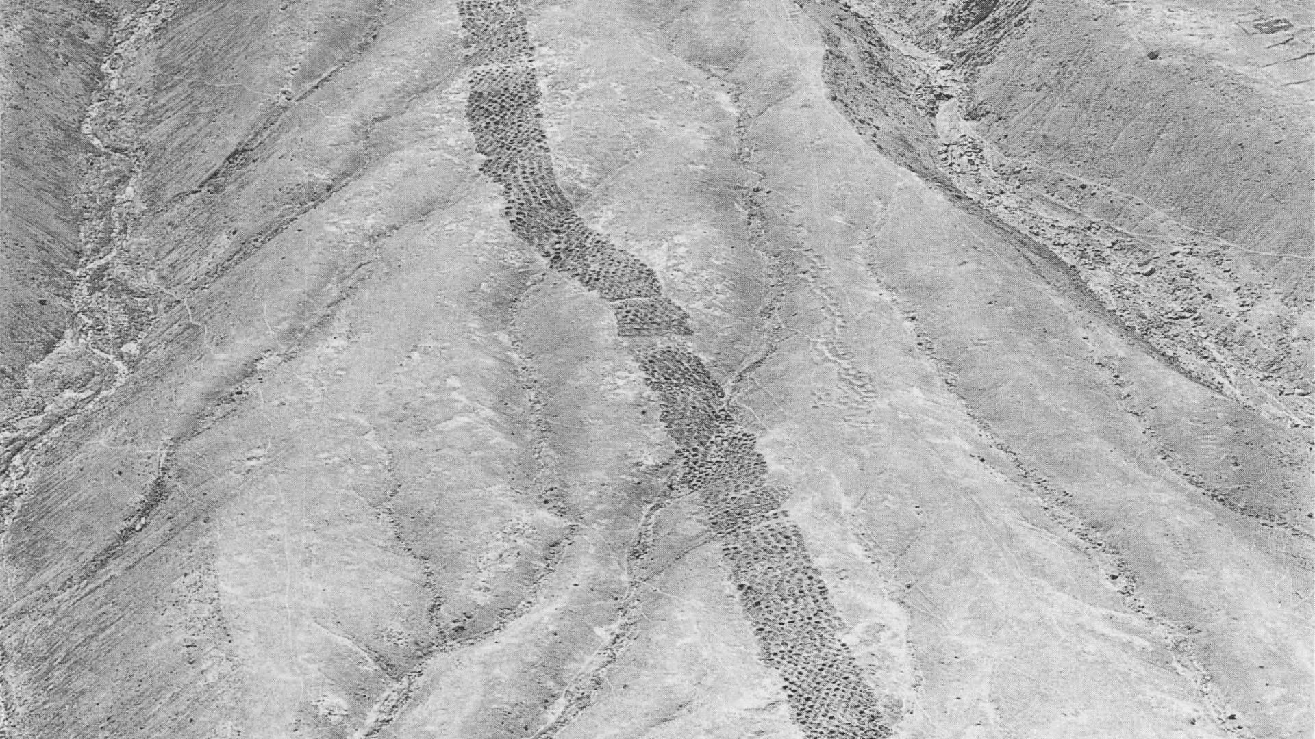
This extraordinary archaeological feature stretches approximately 1.5 kilometers across the arid hillsides, comprising around 5,200 uniform depressions, each measuring 1-2 meters in width and 0.5-1 meter in depth. Arranged in meticulous rows and segmented into distinct areas, the site first captured global attention through 1933 aerial photographs published by National Geographic, yet its purpose has eluded clear explanation until now.
Key Discoveries from Drone Surveys and Soil Testing
A team led by Dr. Jacob Bongers, a digital archaeologist from the University of Sydney, utilized high-resolution drone imagery to uncover mathematical patterns in the pit arrangements, indicating intentional construction rather than haphazard digging. Remarkably, the overall configuration resembles an Inca khipu—a traditional knotted-cord recording tool discovered in the vicinity—hinting at advanced organizational practices.
Microbotanical analysis of soil extracted from the pits detected remnants of maize, a staple Andean crop, alongside reeds commonly employed in basket weaving. These traces imply that ancient inhabitants deposited plant-based goods into the holes, likely transported in woven carriers, facilitating exchanges among traders, farmers, fisherfolk, and merchants via llama caravans or coastal routes.
“Why would ancient peoples create over 5,000 holes in the foothills of southern Peru? Were they for gardening, water capture, or agriculture? While uncertainties persist, our new data offers promising insights supporting innovative theories on the site’s purpose,” remarked Dr. Bongers.
The strategic positioning of Monte Sierpe bolsters this barter-center hypothesis. Located between Inca administrative hubs, at the intersection of pre-Hispanic trade paths, and within the chaupiyunga ecological transition zone linking highlands and coast, it served as an optimal venue for inter-regional commerce. Initially constructed by the pre-Inca Chincha Kingdom for organized trade, it was repurposed under Inca governance for tribute collection and record-keeping.
From Marketplace to Imperial Ledger
“This could represent a pre-Inca marketplace akin to a bustling flea market, drawing a population of about 100,000 for swapping essentials like corn and cotton. These pits essentially acted as social infrastructure uniting communities, evolving into a grand-scale accounting mechanism during Inca times,” Dr. Bongers explained. Questions linger—why is this unique to the Pisco Valley? Might it function as a ‘landscape khipu’?—yet the breakthroughs are exhilarating.
Past theories ranged from defensive structures and storage facilities to water harvesting or fog collection devices, but none fully accounted for the evidence. The integration of aerial drone photography, previously hampered by coastal fog, with sediment microanalysis has illuminated both micro-level details and macro-landscape dynamics.
Interdisciplinary Team and Technological Advances
Dr. Bongers, holder of the Tom Austen Brown Postdoctoral Research Associateship in Archaeology and affiliate of the Vere Gordon Childe Centre at the University of Sydney, spearheaded this effort alongside global collaborators. Professor Kirsten McKenzie, VGCC Director, lauded the work for countering online misinformation and amplifying Indigenous heritage through rigorous science.
Senior co-author Professor Charles Stanish from the University of South Florida highlighted the site’s prior neglect due to its remoteness and lack of developmental threats. Drone tech revolutionized analysis, exposing structured hole segments invisible from ground or elevated vantage points amid perpetual haze. Few surface artifacts complicated prior dating efforts, but precision imaging confirmed its profound significance.
“The mathematical patterning in the holes is spectacular. Paired with comparable findings in nearby valleys, it underscores the site’s role in storage and redistribution. Future studies will trace plant origins, especially medicinals, deepening its intrigue,” Stanish added. The research, published November 10, 2025, in Antiquity, was funded by grants from Franklin Research, University of South Florida, and UCLA’s Cotsen Institute, with permissions from Peru’s Ministry of Culture.